Log in
All resources
Create a design
6,986 Free Images of Image Editing
maps from the earth and its inhabitants, vol. iv
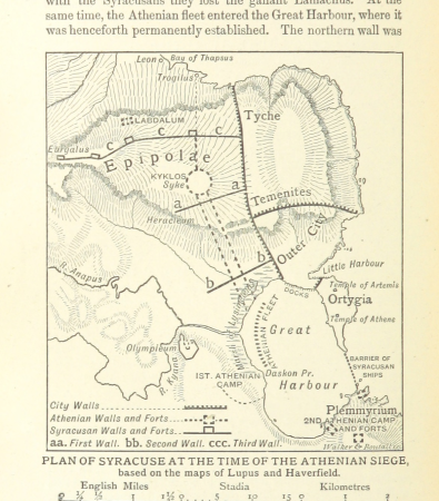
a smaller history of greece, from the earliest times to the roman conquest (1897)
1880s maps of the british isles
maps from the earth and its inhabitants, vol. xiii
maps from the earth and its inhabitants, vol. vii
maps from the earth and its inhabitants, vol. vi
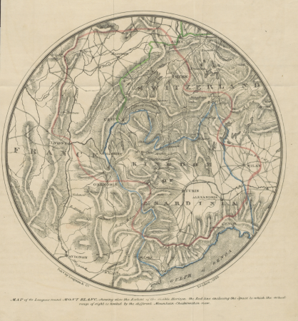
narrative of an ascent to the summit of mont blanc (1830)
a class-book of modern geography (1898)
charles eugène perron
maps indicating exploration
maps from the earth and its inhabitants, vol. iv
1880s maps of the british isles
narrative of an ascent to the summit of mont blanc (1830)
maps of massif du mont-blanc
maps from the earth and its inhabitants, vol. iv
old maps of york
maps from the earth and its inhabitants, vol. iv
old maps of leeds
ghosts & ghoulish scenes
john moyr smith
a smaller history of greece, from the earliest times to the roman conquest (1897)
maps of alexander the great's wars
a smaller history of greece, from the earliest times to the roman conquest (1897)
old maps of ancient athens
a smaller history of greece, from the earliest times to the roman conquest (1897)
ten thousand campaign
maps from the earth and its inhabitants, vol. iv
1880s maps of ireland
maps from the earth and its inhabitants, vol. iv
old maps of sheffield
maps from the earth and its inhabitants, vol. iv
19th-century maps of the isle of man
ghosts & ghoulish scenes
maps from the earth and its inhabitants, vol. iv
old maps of hartlepool
maps from the earth and its inhabitants, vol. iv
1880s maps of the british isles
maps from the earth and its inhabitants, vol. iv
old maps of the firth of forth
maps from the earth and its inhabitants, vol. iv
1880s maps of the british isles
maps from the earth and its inhabitants, vol. iv
19th-century maps of lincolnshire
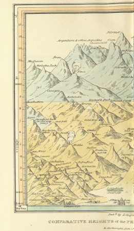
narrative of an ascent to the summit of mont blanc (1830)
mountain height comparison diagrams
maps from the earth and its inhabitants, vol. iv
1880s maps of the british isles
maps from the earth and its inhabitants, vol. iv
1880s maps of the british isles
maps from the earth and its inhabitants, vol. iv
old maps of derby
maps from the earth and its inhabitants, vol. iv
1880s maps of the british isles
a smaller history of greece, from the earliest times to the roman conquest (1897)
old maps of ancient greece
maps from the earth and its inhabitants, vol. iv
1880s maps of scotland
maps from the earth and its inhabitants, vol. iv
old maps of liverpool
a smaller history of greece, from the earliest times to the roman conquest (1897)
maps of the battle of marathon
maps from the earth and its inhabitants, vol. iv
1880s maps of the british isles
maps from the earth and its inhabitants, vol. iv
1880s maps of the british isles
anymp4 retouched pictures
otta mizera
maps from the earth and its inhabitants, vol. iv
maps of ben nevis
a smaller history of greece, from the earliest times to the roman conquest (1897)
battle of thermopylae
maps from the earth and its inhabitants, vol. iv
19th-century maps of kent
maps from the earth and its inhabitants, vol. iv
19th-century maps of county durham
a smaller history of greece, from the earliest times to the roman conquest (1897)
maps of troas
narrative of an ascent to the summit of mont blanc (1830)
mountain height comparison diagrams
maps from the earth and its inhabitants, vol. iv
old maps of the hebrides
the topography of rome and its vicinity (1846)
tabula peutingeriana places in modern italy
maps from the earth and its inhabitants, vol. iv
19th-century maps of lancashire
a smaller history of greece, from the earliest times to the roman conquest (1897)
battle of salamis
maps from the earth and its inhabitants, vol. iv
1880s maps of the british isles
a smaller history of greece, from the earliest times to the roman conquest (1897)
maps of magna graecia
maps from the earth and its inhabitants, vol. iv
19th-century maps of lancashire
the topography of rome and its vicinity (1846)
pratica di mare
a smaller history of greece, from the earliest times to the roman conquest (1897)
old maps of syracuse
maps from the earth and its inhabitants, vol. iv
maps of loch lomond
maps from the earth and its inhabitants, vol. iv
old maps of glasgow
maps from the earth and its inhabitants, vol. iv
old maps of the isle of arran
maps from the earth and its inhabitants, vol. iv
siornoway
old maps of lake titicaca
maps of lake titicaca
maps from the earth and its inhabitants, vol. vii
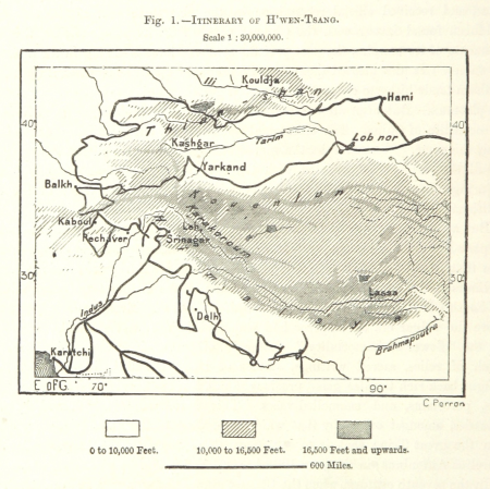
maps of xuanzang's travels
maps from the earth and its inhabitants, vol. xiii
maps indicating exploration
maps from the earth and its inhabitants, vol. iii
1870s maps of belgium
maps from the earth and its inhabitants, vol. iv
maps of loch fyne
maps from the earth and its inhabitants, vol. vii
maps of the yellow river
maps from the earth and its inhabitants, vol. v
1870s maps of norway
maps from the earth and its inhabitants, vol. xi
maps indicating exploration
maps from the earth and its inhabitants, vol. v
charles eugène perron
maps from the earth and its inhabitants, vol. vii
1878 maps of asia
maps from the earth and its inhabitants, vol. iv
peterhead
maps from the earth and its inhabitants, vol. xii
maps of icebergs
maps from the earth and its inhabitants, vol. iv
mouth of tay
maps from the earth and its inhabitants, vol. iv
holyhead
maps of the western cape
breede river
a class-book of modern geography (1898)
east european plain
maps from the earth and its inhabitants, vol. iv
maps of kirkwall
maps from the earth and its inhabitants, vol. vi
maps of the history of russia
maps from the earth and its inhabitants, vol. vii
yarlung tsangpo
maps from the earth and its inhabitants, vol. vi
shchurovsky glacier
maps from the earth and its inhabitants, vol. xvi
1870s maps of panama
maps from the earth and its inhabitants, vol. vi
maps of weather and climate of asia
maps from the earth and its inhabitants, vol. xvii
archaeological sites in ohio
maps from the earth and its inhabitants, vol. ii
1874 maps
maps from the earth and its inhabitants, vol. iii
old maps of halle (saale)
maps from the earth and its inhabitants, vol. xiii
ethnographic maps of africa
maps from the earth and its inhabitants, vol. viii
british raj
maps from the earth and its inhabitants, vol. xviii
treaty of tordesillas
maps from the earth and its inhabitants, vol. iii
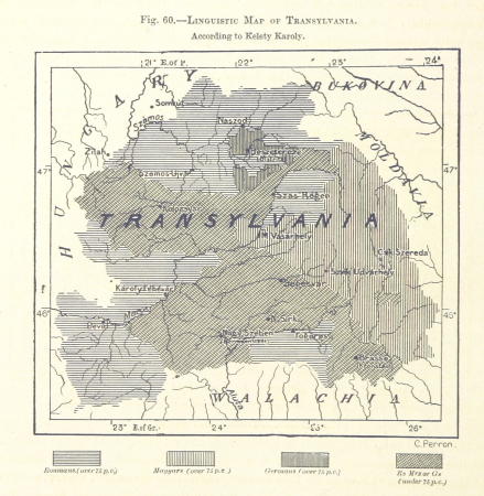
linguistic maps of the balkans
maps from the earth and its inhabitants, vol. vii
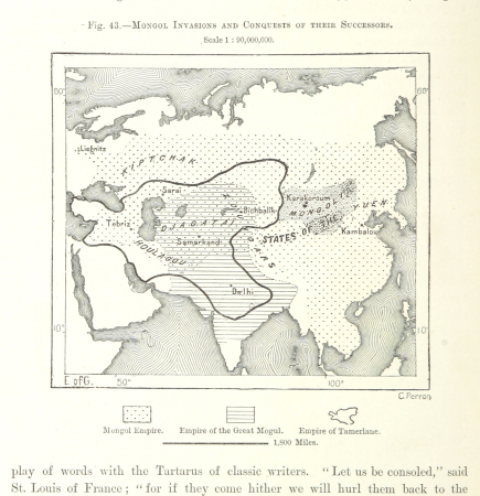
maps of the mongol empire
post-impressionism,pont-aven school,symbolism,synthetism,cloisonnism,impressionism,primitivism
prints and drawings in the los angeles county museum of art
bear
face
battle of spicheren - lithographs after jules férat
battle of spicheren
in den schluchten des balkan (karl may)
peter schnorr
maps from the earth and its inhabitants, vol. iv
glenroy, scotland
maps from the earth and its inhabitants, vol. vi
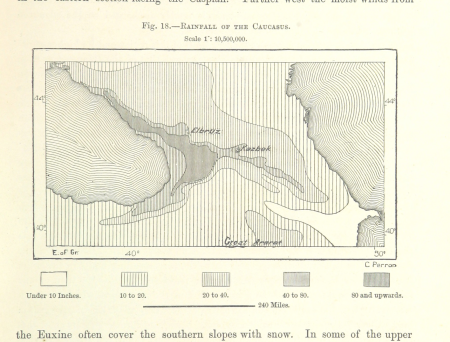
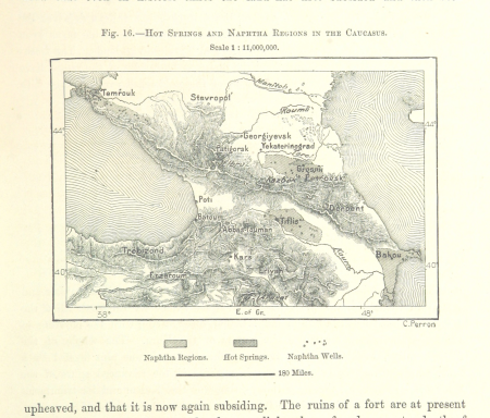
naphtha
19th-century maps of the british isles
19th-century maps of the north sea
maps from the earth and its inhabitants, vol. ix
maps of telegraph lines
maps from the earth and its inhabitants, vol. xiii
maps of telegraph lines
old maps of south africa
maps of the great trek
maps from the earth and its inhabitants, vol. iv
maps of portland, england
maps from the earth and its inhabitants, vol. xvi
1870s maps of panama
maps from the earth and its inhabitants, vol. xv
maps indicating exploration
maps from the earth and its inhabitants, vol. iv
illiteracy in the united kingdom
maps from the earth and its inhabitants, vol. iv
bressay
maps of rivers of senegal
bafing river
maps from the earth and its inhabitants, vol. ix
1870s maps of jerusalem
maps from the earth and its inhabitants, vol. xiii
topographic maps of angola
maps from the earth and its inhabitants, vol. x
19th-century maps of egypt
maps from the earth and its inhabitants, vol. iv
loch etive
dictionnaire populaire illustré de décembre-alonnier-tome 1
boulevard saint-denis (paris)
collections of bibliothèque interuniversitaire de santé
ambroise tardieu
2001 - 2100 of 6,986
Next page
/ 70